Debbie Carlson, for CME Group
At a Glance:
- Following a strong El Niño, La Niña, with its warmer, drier effects on the Corn Belt, hasn’t returned yet
- Impacts of a wet winter and spring have been mostly offset by warmer temperatures
Much of the Midwest saw scorching temperatures to welcome summer, with highs above 90 degrees Fahrenheit, but the Corn Belt could have a fairly benign weather outlook if long-range forecasts hold.
Corn and soybean crops are off to a good start as planting season wrapped up. Weekly crop data from the U.S. Department of Agriculture’s National Agricultural Statistics Service says 84% of the corn crop was in good-to-excellent condition as of mid-June, versus 55% for the same time the previous year. Seventy percent of soybeans are in top shape as well, compared to 54% in 2023.
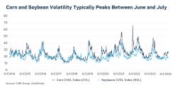
That put some price pressure on CME Group Corn and Soybean futures, both of which have trended lower since mid-May for new crop December Corn and new-crop November Soybeans.
Building up Soil Moisture
Agricultural weather forecasters say a wet winter and spring in much of the Corn Belt set up farmers to start the growing season off right. Joe Woznicki, forecaster at Commodity Weather Group, says while 2024’s spring was one of the top 10 wettest in terms of rain, it also ranked in the top 10 warmest.
“Those warm temperatures really helped us to mitigate some of that wetness and allowed us to keep the planting pace at least pretty close to normal throughout the spring. We didn't see any times where we were lagging behind here during the spring,” he says.
John Baranick, ag meteorologist at DTN Weather, says the active spring storm track supercharged soil moisture across the Midwest, even eliminating long-standing droughts in places like Iowa that were 10-15 inches below normal precipitation levels since 2020.
“That four-year stretch of dryness is essentially gone across the entire Corn Belt, outside of western Kansas. We've gone a long way here to completely eliminate drought and build up a lot of really good soil moisture across almost the entire Corn Belt,” he says.
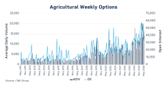
As weather conditions shifted, weekly options trading in corn and soybeans at CME Group rose to record levels. These options allow producers and other market participants to manage risk around short-term, high impact events like a weather change or USDA report. Average daily volume in ag weekly options rose to a record of more than 20,000 in March and nearly matched that total again in May.
El Niño, the weather phenomenon that heats up sea surface temperatures, dissipated in the spring. Meteorologists were waiting for La Niña to take its place, but so far that hasn’t happened, which has come as a surprise. La Niña is characterized by cooler sea surface temperatures and in the Midwest, it can cause ridging patterns, or heat domes.
The past El Niño was one of the strongest since detailed records have been kept in the 1950s, Baranick says, and those “super El Niños” are usually followed by La Niñas the next two following winters.
“I'm actually surprised it's not going to be as strong as some of the models were forecasting. If you look at the ocean temperatures right now, right along the surface versus it's cool, but not super cold out there. If you look just below the surface, there's just a giant pool of cold water, just waiting to come to the surface. All we need is something like the trade winds that go across the equator to really pick up,” he says.
Woznicki says the weather outlook suggests that La Niña could develop, but he doesn’t expect it until at least August or even later into the fall, and there’s no guarantee if it occurs that it will affect the Corn Belt.
“It doesn't necessarily mean that heat and drought is going to set up over the Corn Belt. It could set up on the East Coast, it could set up in the West Coast, as it has frequently in the more recent La Niña years,” he says.
A Hot and Dry Summer
Woznicki’s outlook calls for the Western Corn Belt to have a better chance to see heat and dryness in the later part of the summer, while the Eastern Corn Belt, which has some dryness now, could be better than areas west of the Mississippi.
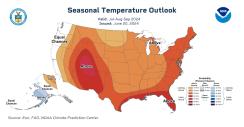
Baranick says DTN’s research, which combines historical looks back and computer models, suggest that upper-level high pressure ridges may settle into the Midwest at various times, bringing hot and dry conditions. There are risks for heat domes this summer, but the key is where the ridges go and if they stay in a particular spot or move throughout the season.
“What we're hoping for is this moving, upper-level ridge throughout the summer,” he says.
In cattle country, the southern Plains and areas north and east of Midland, Texas have had adequate moisture for pasture, while land south and west of Midland are suffering from drier conditions, Woznicki says.
Baranick noted the heavy rain that fell in late June across the northwestern Corn Belt caused extensive flood damage, while an upper-level ridge decreased soil moisture in parts of the Eastern Corn Belt.
“But most areas are sitting in good shape relative to recent years, and especially last year when the entire Corn Belt was facing extensive flash drought conditions. Flash droughts occur when drought occurs quickly, usually due to a lack of rainfall and high heat that saps topsoil moisture,” he says.

